Pedestrian Bridge Engineering Feasibility Study
Introduction
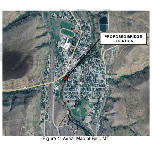
The previous swinging pedestrian bridge at 2nd Avenue South and Castner Street in Belt, MT was taken down around 2018. Since then, the Belt Park and Rec Board has been fundraising for a new pedestrian bridge at the same location. The Board hired TD&H Engineering to conduct an engineering feasibility study to analyze and document the viability of a new bridge and explain the overall process of a bridge project. See Figure 1 for the proposed location of the new pedestrian bridge, which is the same site where the previous swinging bridge was located.
Site Visit
On October 3, 2024, Mr. Brady Lassila, PE (TD&H) and Ms. Sarah Bridges, EI (TD&H) performed a site visit at the proposed bridge location. The purpose of this visit was to determine site constraints and constructability challenges, such as conflicting utilities, possible wetlands, and site access. Client representatives who also attended the site visit were Rolf Johnson of Belt Park and Rec, Sue Reardon of Belt Park and Rec Board, and Becky Gorton of Belt City Council.
Bridge Feasibility
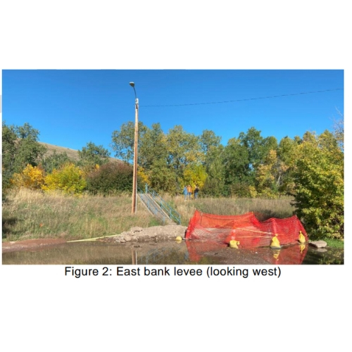
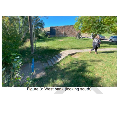
Proposed Bridge Location The east end of the bridge will be located near the intersection of River Drive and 2nd Avenue South, and the west end of the bridge will be located off Castner Street near the Belt Museum. There previously was a swinging pedestrian bridge at this site, approximately 120 feet long, that was removed in 2018. Currently, there are concrete stairs on each side of the creek where the previous bridge was located. It is likely that these stairs will remain and be reused for the new project.
Site Constraints
To install a new bridge, clearing and grubbing would be required to clear vegetation off the stream banks before installing a new bridge. The area has become overgrown since the old bridge was removed. While utility locates (811 One Call) were not included in the scope of this project, visible utilities were observed during TD&H’s site visit. On the west bank, visible utilities include overhead power and storm drain. On the east bank, visible utilities include overhead power, buried communication line, and water. The overhead power lines would likely need to be temporarily moved to construct the new bridge with a crane. Utility locates would be necessary for the full design survey at a later date.
Site Access
With tree clearing and utility relocations, cranes could likely be positioned on each bank to install the new bridge. Temporary fill dirt may be necessary on the east bank to provide a gentler slope for a crane to climb. For the new bridge, ADA access is easily achieved on the west bank. On the east bank, the existing concrete stairs, which do not meet ADA standards, should be left in place to avoid floodplain permitting complications. Some type of ramp system or alternate path along the top of the levee could be considered.
Land Ownership
The museum lot and the city streets leading up to the stream are City property. The streambank is a separate parcel. Per email from Lynn Schilling (City of Belt ClerkTreasurer), the land on which your proposed bridge project would take place is currently owned by the Montana Department of Environmental Quality (DEQ). They acquired it in a quiet title action in 2018 and have to date, not deeded it back to the City of Belt. The town would either need to purchase the land or an easement to construct the new bridge, if DEQ is willing to allow it.
Superstructure
The approximately 120-foot span across Belt Creek would be simple to achieve with various types of construction. The superstructure of this bridge could be a steel truss, steel girder, or concrete girder system. The following are more detailed descriptions for the superstructure options.
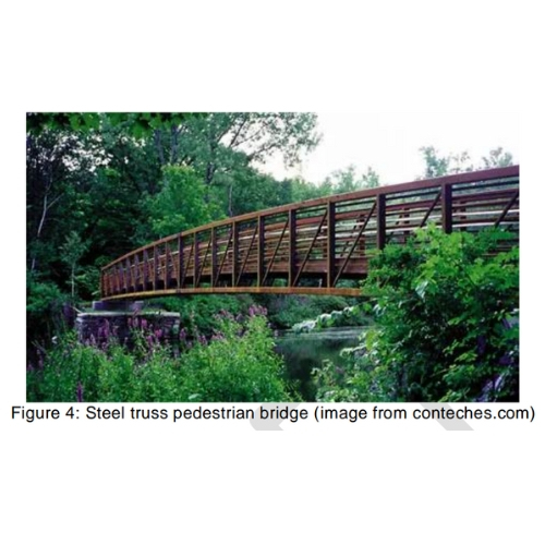
a. Prefabricated Steel Trusses with Concrete or Wood Deck – This construction would consist of steel trusses, steel floor beams, steel stringers, and a cast-in-place concrete or wood deck. Steel trusses are often lighter weight than steel girders for comparable spans. With protective surface treatments and proper maintenance, steel is corrosion resistant. This type of truss bridge is very common for pedestrian bridges. An example of this bridge type is shown in Figure 4.
b. Steel Girders with Concrete Deck – Steel is lighter weight than concrete for comparable girder spans. With protective surface treatments and proper maintenance, steel is corrosion resistant. The cast-in-place concrete deck acts compositely with the girders to provide additional strength to the system. Based on recent Montana bridge projects, the steel girder alternative would likely cost more than the prestressed concrete girder alternative for the superstructure.
c. Prestressed Concrete Girders with Integral Deck – This type of prestressed concrete is also commonly known as bulb-tees. The integral deck top flange allows the girders to be placed adjacent to each other and create the walking surface without the need to construct a cast-in-place concrete deck after the girders are placed. The integral deck allows for a shorter construction timeline and lower construction cost. The concrete girders are corrosion and deterioration resistant.
Foundations
The foundation for this bridge would likely need to utilize a deep system that bears on bedrock. Previous geotechnical evaluations for other projects in nearby areas indicate bedrock is likely around 40 feet below grade. Drilled concrete shafts or driven steel piles could be utilized for the foundation, and details of each have been outlined below.
a. Drilled Shafts – Drilled shafts consist of cast-in-place concrete, and a steel reinforcement cage placed in an augered hole. In some cases, such as drilling into bedrock, open hole drilling methods are performed. However, in cases of weak or unstable soil, which is possible due to the levee, temporary casing may be needed to prevent sloughing until concrete placement is completed. The drilled shaft would likely need to bear on bedrock in this location. Drilled shaft construction is typically more expensive than driven piles.
b. Driven Piles – Steel H-piles or pipe piles are commonly used for bridge foundations. Piles are required when the surface soil cannot support bridge loads due to insufficient bearing strength, settlement concerns, or scour concerns. The piles are driven through the soil profile using a crane-mounted pile driving hammer.
Permitting Feasibility
Environmental Scan TD&H performed a high-level review of public databases for potential environmental concerns. Database research included potential hazardous materials, water quality contamination, cultural resources, wetlands, and threatened and endangered species.
No hazardous materials or water quality contamination concerns were found in the immediate project vicinity.
The Belt Museum (former Belt Jail) was built in the late 1890s and is on the National Register of Historic Places. The bridge should be positioned to avoid impacting this property.
There are possible small fringe wetlands along the stream bank, but no large wetlands were identified on the National Wetlands Inventory. There do not appear to be any wetland concerns that would prohibit a bridge.
There are no listed threatened or endangered (T&E) species, nor critical habitats, in the project vicinity. The Monarch Butterfly is a candidate endangered species that may be present in the project area. There do not appear to be any T&E concerns that would prohibit a bridge.
Bald Eagles and Golden Eagles are protected under the Bald and Golden Eagle Protection Act and Migratory Bird Treaty Act (MBTA). Eagles and other migratory birds are likely to be found within the project area. New bridge construction would need to follow requirements of the MBTA, such as timing restrictions on tree and shrub removal.
Stream Permits and Corresponding Resource Agencies
The following permits are required to construct this bridge:
a. Montana Natural Streambed and Land Preservation Act (310)
b. City or County Floodplain Development Permit
c. Federal Clean Water Act (404 Permit)
d. Short-Term Water Quality Standard for Turbidity (318 Authorization)
All four of these permits utilize the Joint Application for Proposed Work in Montana’s Streams, Wetlands, Floodplains, and Other Water Bodies. At this time, there are no apparent concerns regarding the 310 or 318 permits.
The 404 Permit is administered by the US Army Corps of Engineers (USACE), and among other things, regulates the amount of fill deposited into streams and wetlands. The USACE also regulates levees. Based on information provided by Mr. Rolf Johnson, the Belt levee is not certified by the USACE. This non-certification issue will likely require extensive coordination with the USACE during the bridge design and permitting process to ensure project success.
Floodplain Regulations
Per an email from the City of Belt Clerk-Treasurer, the floodplain program is “somewhat in limbo.” Montana DNRC’s website indicates the City of Belt is the regulatory authority for floodplains. However, the FEMA website indicates Belt is currently on probation for failure to enforce. For this preliminary report, it was assumed that the floodplain requirements for this site will be those published for Cascade County. While minor differences may exist, the primary requirements will include no new obstructions in the floodway and appropriate freeboard for the new bridge. Belt Creek in this area has a delineated floodplain based on a detailed study, shown in Figure 5. The location of the pedestrian bridge is shown as cross-section M on the FEMA map. The Flood Insurance Rate Map (FIRM) shows a 100-year water surface elevation (base flood elevation or BFE) of 3516 feet at cross-section M. Field survey of the elevations of the existing stairs to determine their elevation compared to the BFE will be necessary, but it appears likely the top of the existing stairs is significantly higher than elevation 3516 feet. This would allow a new pedestrian bridge to be constructed using the existing stairs on both sides, without any impact to the floodplain or the floodway. With no impact to the floodplain, a no-rise certification could be prepared. This should allow the Town of Belt to issue a floodplain permit. Cascade County regulations would require 2 feet of freeboard from the 100-year water surface elevation to the low beam of the bridge. The bridge will need to meet the floodplain requirements of the Town of Belt, but they may default to the Cascade County regulations.
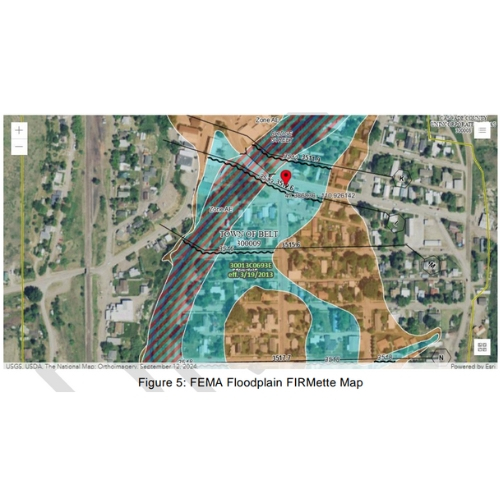
A 2024 floodplain study of Belt Creek was completed by Silver Jackets (an interagency program). This study appears to have developed a two-dimensional (2D) model of Belt Creek in the Belt area, including at the proposed location of the pedestrian bridge. TD&H attempted to contact Montana Department of Natural Resources and Conservation (DNRC) to obtain an electronic copy of this model, but we have not received a response. The model would help verify the assumption that the new pedestrian bridge could be constructed above the 100-year floodplain. It is unclear if this study will result in revised FEMA floodplain maps or not. Preliminary analysis and engineering judgement indicates freeboard and no-rise requirements can likely be met by the proposed pedestrian bridge. However, regulation of construction within the floodway varies between jurisdictions.
Cost Estimates
Based on recent experience with pedestrian bridge projects, a rough order of magnitude (ROM) cost estimate for a pedestrian bridge 120 feet long and 8 feet wide is approximately $500,000. A ROM cost estimate for design fees is approximately $100,000.
Funding sources that may be available to the Belt Park and Rec Board include:
• Montana Coal Endowment Program (MCEP) https://commerce.mt.gov/Infrastructure-Planning/Programs-and-Services/MontanaCoal-Endowment-Program/
• Montana Department of Transportation (MDT) Transportation Alternatives (TA) https://www.mdt.mt.gov/mdt/ta-application.aspx
• A multitude of Federal grant opportunities through the US Department of Transportation and the Bipartisan Infrastructure Law (BIL) https://www.transportation.gov/bipartisan-infrastructure-law/bipartisaninfrastructure-law-grant-programs
Schedule
A project of this type is estimated to take approximately 6-12 months to design. The next design steps include land survey, hydraulics design, bridge design, site/civil design, utility relocations, environmental documentation, and permitting.
A project of this type is estimated to take approximately 2-3 months to construct. The construction window will likely be dictated by Montana Fish Wildlife and Parks (FWP) to avoid fish spawning seasons. We suggest waiting to take this project into the design phase until the Town of Belt resolves its probation with FEMA.
We suspect it will be very difficult to impossible to obtain a floodplain permit while the Town’s floodplain program is in limbo. Likewise, it would be difficult to work with the floodplain administrator during the design phase to establish what the design criteria are.
Conclusions
There are two major concerns that impede the feasibility of a new pedestrian bridge.
First, floodplain development regulations are unclear at this time. The Town of Belt’s floodplain program is “in limbo.” Even with firmly established floodplain regulations, this project could be tricky because the bridge is being built within the floodway. With the Town’s program “in limbo,” the regulations may be even more difficult to comply with. However, it seems reasonable that a new bridge could be constructed above the 100-year flood elevation with adequate freeboard, with the east abutment constructed on top of the levee. A No-Rise hydraulics engineering analysis could be proven. However, it is ultimately the Floodplain Administrator’s call on whether development within the floodway is allowed or not. We suggest waiting to take this project into the design phase until the Town of Belt resolves its probation with FEMA.
Second, DEQ owns the land on both sides of the creek. The town would need to either purchase the land or an easement to construct the new bridge, if DEQ is willing to allow it.
We suggest waiting to take this project into the design phase until your Board has confirmation from DEQ that a bridge can be built here.
